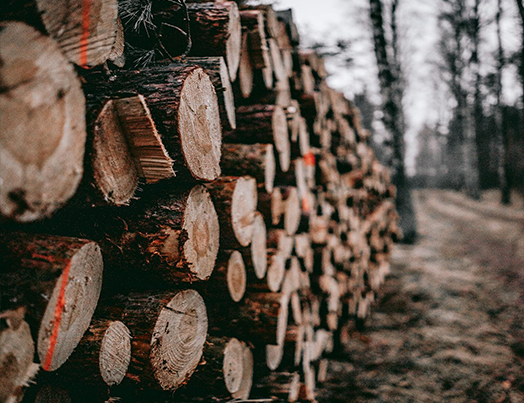
1. The Silicon Axe: How AI-Powered Automation is Redefining Timber Harvesting
By 2026, AI-powered automation has become industry standard, with over 40% of timber harvesting equipment featuring advanced AI systems. Modern harvesters use computer vision and deep learning for real-time species recognition, enabling precise grip, torque, and cutting adjustments. This reduces operator error and optimizes the "bucking" process, cutting wood waste by up to 30%. The synergy between human operators and autonomous systems is setting a new efficiency benchmark in the global timber market.
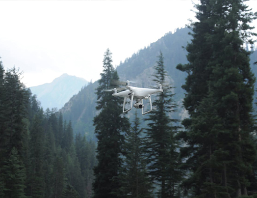
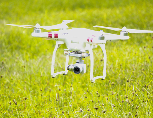
2. The Future of Forestry: 7 Game-Changing Trends in 3D Drone Mapping for 2026
Advanced 3D drone mapping has revolutionized forest surveying in 2026, shifting from post-processing to real-time edge computing that detects anomalies mid-flight. LiDAR integration has become industry standard, producing sub-10 cm accuracy maps that penetrate dense canopies to reveal the forest floor. AI-driven automated feature extraction, digital twins for tracking growth over seasons, and swarm mapping with multiple drones are enabling forest managers to move from reactive conservation to proactive, precision-based stewardship.
3. Revolutionizing Silviculture: The Rise of Autonomous Below-Canopy Drone Intelligence
Deep Forestry has engineered drones capable of autonomous flight beneath the forest canopy—previously impossible for GPS-dependent systems. Combining LiDAR for 3D structural mapping and hyperspectral sensing for species identification, these units conduct comprehensive digital tree censuses, capturing precise locations, species data, and timber volume calculations. This technology eliminates traditional margins of error, enabling more sustainable harvesting and effective reforestation, turning the "smart forest" from concept into reality.

4. The AI Field Assistant: How Generative Tools are Transforming On-Site Forestry
Generative AI tools like UPM's Aarnibot are transforming field operations by delivering real-time regulatory and site-specific information directly under the canopy. Foresters can instantly access critical parameters—stream buffer widths, retention tree requirements—reducing compliance errors. Beyond data retrieval, these AI companions bridge complex regulatory frameworks with practical field execution, empowering professionals to make high-stakes decisions confidently while reinforcing consistent application of conservation standards.

5. The Digital Green Ledger: How Blockchain is Transforming Carbon Credit Integrity
Post-COP30, blockchain technology is emerging as the primary tool for carbon credit transparency. Tokenizing credits on immutable ledgers creates a permanent, traceable lifecycle—from forest issuance to corporate retirement—eliminating fraud and double-counting that have historically hindered voluntary carbon markets. As reforestation projects adopt these decentralized systems, investors gain verified confidence that contributions drive genuine climate action, making the bridge between forest conservation and global climate finance more robust and reliable.

6. Precision on the Slopes: How Autonomous Robots are Transforming the Future of Reforestation
Autonomous tree-seeding robots are rewriting reforestation by navigating steep slopes and remote terrain previously inaccessible to human planters. Unlike aerial seeding—which suffers from poor accuracy—these robots identify optimal planting spots with surgical precision, reducing seed usage by up to 80% without compromising results. By unlocking millions of hectares of degraded land and placing every seed where it has the highest survival probability, this robotic revolution represents a vital bridge between innovation and urgent ecological restoration.
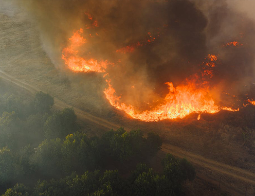
7. Drones to the Rescue: The High-Tech Race to Re-Green Our Scorched Landscapes
Flash Forest is using advanced drone swarms to dramatically accelerate post-wildfire reforestation, planting up to 20,000 seed pods per day across fire-damaged terrain too dangerous for human crews. Proprietary biological pods protect seeds and deliver essential nutrients, maximizing germination rates in harsh post-burn conditions. By scaling restoration through automation, this technology provides a repeatable, efficient solution to the increasing frequency of global wildfires, turning scorched earth into thriving ecosystems in record time.
8. Space-Based Sentinels: How Satellite IoT is Transforming Early Forest Fire Detection
Kinéis is deploying a constellation of 25 nanosatellites linked to ground-based sensors on individual trees to detect wildfires during the critical slow-combustion phase—before they become uncontrollable. Unlike thermal satellites obscured by clouds or canopy, these sensors capture heat and chemical signatures at ground level and relay alerts through the orbital network within 15 minutes. This rapid-response system allows firefighters to intervene while blazes are still manageable, protecting biodiversity in the planet's most remote and vulnerable ecosystems.
9. From Seeds to Sky: How Budget-Smart Drones Are Revolutionizing Reforestation
Drone technology is cutting reforestation costs by 70%, replacing labor-intensive ground planting with fast, precise aerial systems. Companies like AirSeed use bio-tuned seed capsules packed with nutrients, combined with AI-driven mapping to identify optimal planting locations with surgical accuracy. A single drone team completes in days what previously took months of manual labor. By reducing human error and optimizing seed delivery timing, these systems are making reforestation not just cheaper, but significantly more effective.
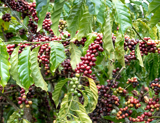
10. Saturation and Science: How AI is Redefining Coffee Plantation Mapping
Chinese researchers have developed a high-precision mapping technique using Machine Learning and Sentinel-2 satellite data, achieving 95% accuracy in identifying coffee plantations. The system analyzes multi-spectral imagery and phenological changes throughout the year, distinguishing coffee shrubs from visually similar subtropical vegetation—overcoming traditional challenges of cloud cover and crop overlap. The resulting granular maps enable better yield forecasting, efficient resource allocation, and deeper understanding of how coffee ecosystems respond to environmental shifts, signaling a new era for precision agriculture.
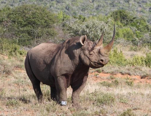
11. The AI Guardians of the Wild: How Tech is Saving Rhinos
Imagine endangered animals with digital bodyguards, sending silent alarms when danger threatens. This isn't sci-fi; it's AI-powered rhino watches, a game-changing conservation strategy being used in countries like South Africa to safeguard rhinos. These systems use wearable collars with GPS and sensors to track rhinos. AI analyses each animal’s normal behaviour and identifies abnormalities, such as sudden movement or stillness, triggering instant alerts. Alerts are graded by severity and sent to rangers via networks like LoRa, often integrating with EarthRanger for monitoring. Companies like Rouxcel Technology in South Africa are leading this effort, with over 1,200 AI-enabled RhinoWatches deployed. Their solar-powered collars not only enhance security but also provide invaluable data for research.
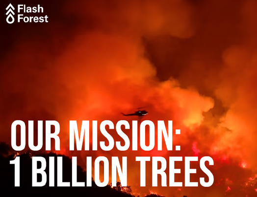
12. Flash Forest: How AI Drones Are Reforesting the Planet—One Billion Trees at a Time
Flash Forest, a Canadian startup is using AI-powered drones to plant trees at scale, faster and more efficiently than traditional methods. Their bold mission? Plant one billion trees by 2028. Flash Forest is a reforestation tech company combining artificial intelligence, drones, and ecological science to restore forests in areas hit hardest by wildfires, deforestation, and climate change. By planting trees faster and smarter, Flash Forest is helping combat climate change, restore degraded ecosystems, and support wildlife.
13. Modernizing Forest Management
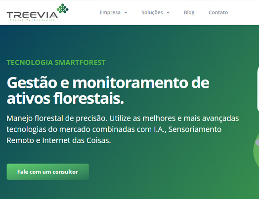
Treevia, also known by its app name SmartForest, is a Brazilian forestry technology platform that combines IoT, mobile tools, and AI to modernize forest management. Developed by Treevia Forest Technologies, the platform uses sensor-equipped devices like digital dendrometers to monitor tree growth and environmental conditions in real time. This data is analyzed using advanced statistical and AI models to support decision-making for forest inventory, productivity tracking, carbon monitoring, and planning. The platform is designed for ease of use in the field via its mobile app, while also offering robust data analytics and reporting capabilities through the cloud. Recognized globally—including with a 2024 iF Gold Design Award—Treevia is used to manage over 100,000 hectares of forest, with ambitions to expand monitoring to one billion hectares by 2030. It is especially useful for forestry companies, researchers, and sustainability projects that require accurate, real-time forest data. By digitizing and automating traditionally manual forestry processes, Treevia plays a critical role in sustainable forest management, carbon tracking, and compliance in the forestry and natural resource sectors.
14. DIGITAL TWINS IN FORESTRY
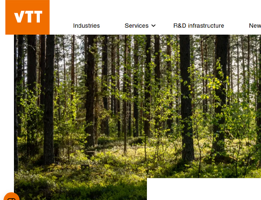
Have you ever wondered how we can keep tabs on the world's forests? VTT, which is one of Europe’s leading research institutions, is leading an exciting initiative called the Digital Twin of the World’s Forests. This project, part of the European Union’s Destination Earth programme, involves a consortium of partners from Finland, Germany, Poland, and Romania. The goal? To create a detailed global model of forests that can monitor health, growth, carbon sequestration, and biodiversity with high precision—even down to 10 square meters. This isn’t the first time VTT has ventured into the world of digital forests. They previously worked on the Forest Digital Twin Earth Precursor (Forest DTEP) between 2020 and 2021, funded by ESA. These prototypes combined satellite data from Sentinel/Copernicus, drone footage, and other remote-sensing sources with AI and cloud processing. The result was impressive models showing both above-ground structures and underground ecosystem processes. All this data gets integrated into VTT’s Forestry TEP platform, which uses JupyterLab interfaces and Docker-based processing modules. This makes forest data accessible to researchers, policymakers, NGOs, and private companies alike. Imagine being able to peek into a virtual forest from anywhere in the world! Looking ahead, VTT aims to roll out a full global forest digital twin within five years. This ambitious project will provide a unified, cross-border resource for monitoring carbon balance, simulating climate impact scenarios, and supporting sustainable forest management decisions globally. Keep an eye on this space—it’s going to revolutionize how we understand and protect our forests!

15. Acoustic Monitoring for Biodiversity Conservation
Costa Rica: Researchers are employing bioacoustics to monitor ecosystems by analyzing sound recordings. This approach helps in tracking species like the bellbird and assessing conservation efforts. The method combines human and natural sounds to detect ecological changes and threats.
16. Monitoring Biodiversity in Remote Areas
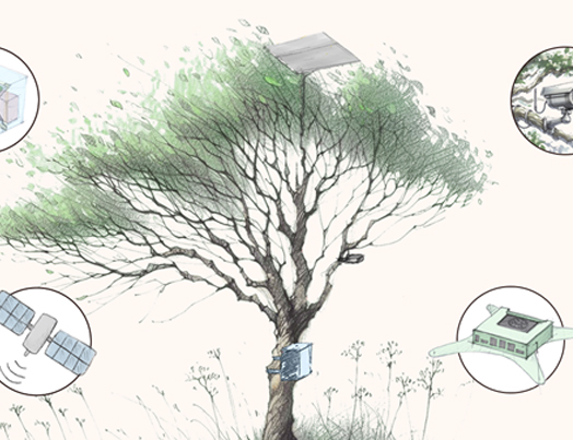
SPARROW is an AI-driven edge computing solution built to operate autonomously in the remotest corners of the planet. It is solar-powered and equipped with advanced sensors that collect biodiversity data from technologies typically used by researchers, including camera traps, acoustic monitors and environmental detectors. Once collected, SPARROW processes this data using Microsoft’s PyTorch Wildlife, an open-source platform designed to empower conservation scientists with AI tools that make it easier to develop, use and share deep learning models for wildlife conservation applications. Data processing takes place on low-energy edge GPUs and the resulting critical data is transmitted via low-Earth orbit satellites directly to the cloud, where researchers can see and use actionable, real-time insights.
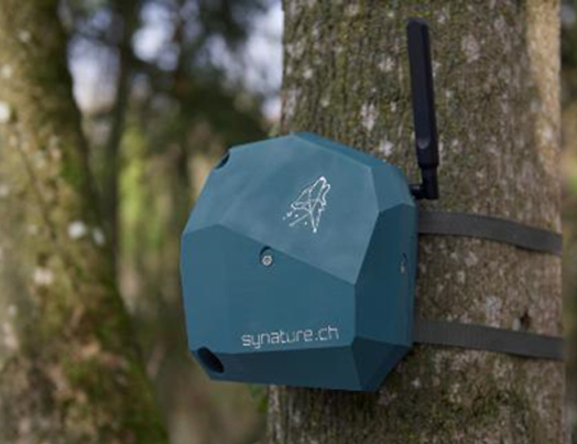
17. RECORDING and ANALYZING ANIMAL SOUNDS
Synature, an early-stage startup co-founded by Noah Schmid (CTO) and Olivier Stähli (CEO), has engineered an advanced microphone system designed to record and analyze animal sounds for the purpose of supporting environmental research and conservation efforts. This innovative system allows organizations, researchers, and consultants to study animal behavior, evaluate environmental changes, and produce data that can inform policy decisions. Furthermore, it can be employed to assess the impact of habitat alterations, such as the creation of nature reserves or infrastructure development. Synature's mission is to quantify biodiversity by gauging the health of ecosystems. The company achieves this through bioacoustics and the application of AI and signal processing techniques to the collected data. Synature provides a comprehensive solution that includes autonomous recorders transmitting audio recordings from the field, automated analysis of the acquired data, and a dashboard that presents the information in an easily interpretable format.

18. Bezos Earth Fund
On May 21, 2025, the Bezos Earth Fund announced 24 Phase I grants awarded under its AI Grand Challenge for Climate and Nature, an initiative aimed at using artificial intelligence to address environmental challenges such as illegal fishing and decarbonizing power grids. Each project will receive a $50,000 Phase I grant, totaling $1.2 million in initial funding. In Phase II, later this year, up to 15 initiatives will be selected to receive implementation grants of $2 million each to further develop their solutions over a two-year period. Launched with a commitment of up to $100 million, the AI Grand Challenge funds ideas to explore AI's potential in addressing climate change, biodiversity loss, and other environmental issues.
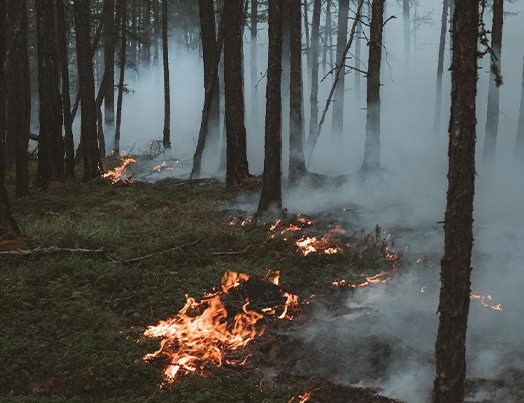
19. Drones that detect and extinguish wildfires
Dryad Networks, a German startup specializing in wildfire technology, leverages artificial intelligence (AI) and drones to detect wildfires within ten minutes of ignition. Their system, Silvanet, combines cutting-edge technologies to pinpoint and locate fires in vast and remote areas, even those that are off-grid, and sends immediate alerts upon detection. The process begins with the installation of Silvanet gateways, small devices placed on trees that use radio and satellite communications to form a network throughout the forest. The next component involves sensors powered by solar energy and AI. These sensors, also installed on trees, detect gases like hydrogen and carbon monoxide and measure factors such as temperature, humidity, and air pressure to spot fires in their early smoldering phases. When a fire is detected, the sensors use the communication network created by the gateways to alert local firefighters of the exact location via email or text message.
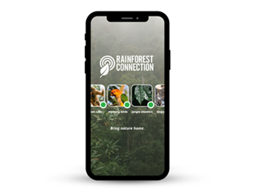
20. Tech that listens and guards the forests
Rainforest Connection (RFCx) employs their ‘Guardian System’ to monitor forests and wildlife for illegal logging and poaching. Unlike visual-based tracking systems such as drones or satellites, RFCx uses acoustic sensors to listen to the ecosystem soundscape at specific locations. This approach produces real-time data on deforestation and poaching activity, facilitating timely interventions. The Guardian hardware is a solar-powered acoustic streaming device installed in tree canopies, equipped with a sensitive external microphone that captures ambient sounds within an area of up to 3 km², depending on the source's proximity. The “Guardians” upload continuous recordings of the environmental soundscape, transmitting the audio to the cloud for analysis. An alert system powered by artificial Intelligence (AI) and machine learning provides rapid insights into activities within forest ecosystems, identifies potentially harmful behavior, and assists rangers in locating and halting detrimental actions as they occur.
21. Will Forests Monitor Themselves in The Future?
Scientists at the Kaunas University of Technology (KTU), Lithuania develop Advanced AI-Powered Monitoring Systems For Real-Time Predictive Analytics. KTU scientists have developed advanced systems for monitoring forests, including a Forest Regeneration Model and a Sound Analysis System. The Forest Regeneration Model, utilizing Markov chains and multidirectional time series decomposition, predicts tree growth and mortality rates to enhance sustainable forestry practices, particularly in adapting to climate change. The Sound Analysis System employs BiLSTM models to detect wildlife activity and assess noise pollution, aiding biodiversity conservation and urban planning. These innovations address challenges in forest monitoring caused by climate change, pests, and human activity, offering real-time detection and predictive analytics. Additionally, KTU's technologies are adaptable for broader environmental monitoring, such as water quality and air pollution, although implementation in different ecosystems requires tailored solutions.
22. AIM4Forests: Advancing Forest Monitoring with AI Solutions
AIM4Forests is a five-year program launched in 2023 by the Food and Agriculture Organization (FAO) and funded by the United Kingdom, designed to support forest monitoring using technologies like AI and remote sensing. The initiative aims to improve the accuracy of forest carbon measurements and enhance sustainable forest management practices worldwide. The program integrates repeated ground-based forest inventory data with AI-powered models, such as the MATRIX model developed by Dr. Jingjing Liang. This model uses data from over 1.8 million forest plots globally, providing both local and global insights into forest dynamics. AIM4Forests also prioritizes making data accessible and transparent, offering a global map and database to help countries with limited resources report accurate greenhouse gas removals. Additionally, it strengthens national forest inventories and promotes international collaboration through knowledge-sharing and best practices.
23. ESA's Biomass Satellite: Mapping Global Forest Carbon
In April 2025, the European Space Agency (ESA) initiated the Biomass satellite project, a significant effort aimed at accurately mapping and measuring the world's forests. The satellite is equipped with a 40-foot deployable P-band synthetic aperture radar (SAR) antenna, which is the largest ever launched into space. It will orbit Earth 15-16 times daily over the next five years. The primary objective of this mission is to measure woody biomass, which is essential for understanding the planet's carbon storage capacity and the impact of deforestation on climate change. The satellite's radar technology can penetrate forest canopies to detect tree trunks and large branches, enabling consistent, global mapping of forest biomass for the first time. By providing accurate, continuous data on forest density and changes over time, the Biomass satellite is expected to significantly enhance conservation policy, land management practices, and climate models. The findings will directly support international carbon accounting commitments, biodiversity protection strategies, and sustainable forest management worldwide.
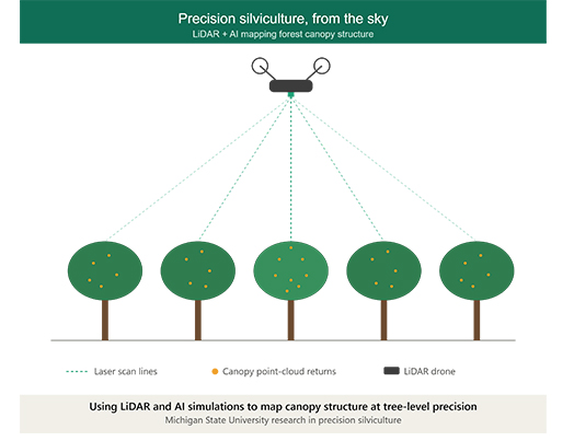
24. Aerial Digital Twins: Michigan State University Deploys LiDAR & AI Simulations for Precision Silviculture
Michigan State University researchers have introduced fully integrated aerial LiDAR scanning paired with predictive AI modeling to map entire timber stands. The AI simulates various thinning treatments before a single saw touches a tree. While ground foresters physically survey only 1% to 5% of a total stand, aerial LiDAR accurately maps and counts 90% to 95% of the total canopy volume in a fraction of the time.
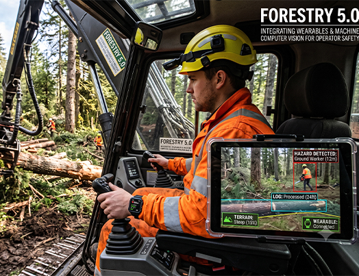
25. Forestry 5.0: Integrating Wearables and Machine Computer Vision for Operator Safety
A comprehensive framework for "Forestry 5.0" showcases the integration of smart Personal Protective Equipment (PPE) and machine-vision camera arrays to reduce industrial logging hazards. Systems leverage the MediaPipe posture framework to actively detect high-risk musculoskeletal strains on ground workers, while 360-degree machine cameras automatically shut down heavy forwarders if a human enters a blind spot.
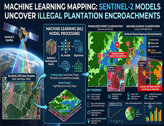
26. Machine Learning Mapping: Sentinel-2 Models Uncover Illegal Plantation Encroachments
A new spatial model leveraging European Space Agency Sentinel-2 satellite data and machine learning classifiers has successfully mapped commercial plantation boundaries in the Upper Blue Nile basin. The open-source pipeline isolates localized tree species signatures, allowing environmental protection agencies to distinguish between native conservation forests and commercial monocultures with high precision.
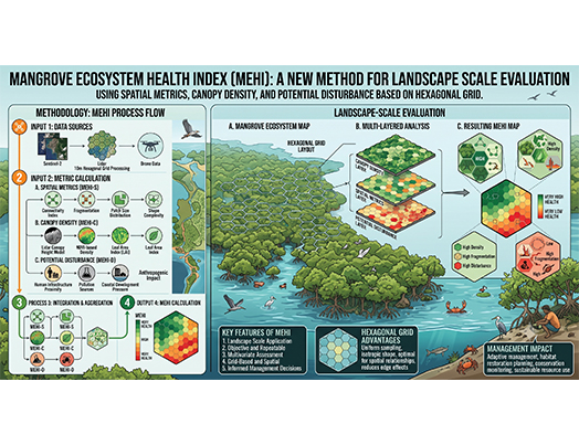
27. Automated Grid Infrastructure: The Hexagonal Mangrove Ecosystem Health Index (MEHI)
Researchers have developed the Mangrove Ecosystem Health Index (MEHI), a spatial tracking tool that breaks coastal forests into structured hexagonal grids to evaluate landscape degradation. By blending remote sensing canopy metrics with automated structural indicators, MEHI gives regional authorities a color-coded dashboard map to direct precision restoration efforts
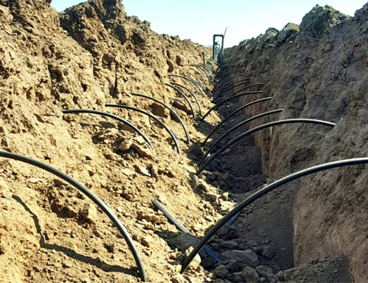
28. Sensor-Driven Automation: Smart Subsurface Drip Systems for Agroforestry Cultivation
A pioneering integration of automated sensor arrays with subsurface drip irrigation has successfully optimized soil moisture profiles in challenging, highly arid agroforestry zones. Real-time underground sensor telemetry adjusts moisture delivery dynamically, cutting water expenditure by 30% while maintaining target sapling growth cycles.
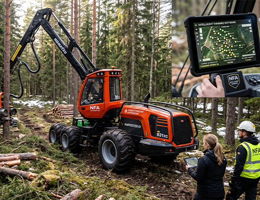
29. AI-Assisted Selection: Nordic Forestry Automation Rolls Out Intelligent Thinning Software
Nordic tech firms have commercialized a smart thinning assistance system that sits inside the cabins of standard heavy harvesters, operating as a co-pilot for the human driver. Using continuous spatial laser scans, the on-board AI highlights precisely which trees should be marked for removal to maximize value recovery while ensuring the surrounding ecosystem remains completely undisturbed.